
Reinforcement Learning in practice…
Étiquette : mobility (Page 5 of 8)

« La jeune entreprise girondine, lauréate du prix de la mobilité Le Monde Smart Cities en 2016, est passée d’applications prédictives sur le vélo, à celles sur tous les types de mobilité. Elle mesure maintenant l’impact des aménagements urbains sur les piétons ».
Source : Qucit : « mathématiser la ville » pour prédire les comportements humains

« La voiture va devenir le troisième espace de vie, après le domicile et le travail : il faut occuper cet espace, vous pourrez vous y relaxer, vous divertir… vous pourrez faire plein de chose dans votre voiture puisque vous ne conduisez plus » – Edzard Overbeek, CEO de Here.
Source : Les nouveaux défis de la cartographie routière pour les voitures autonomes
L’imagination semble bien en panne… Des véhicules avec moins de passagers, qui prennent plus de place et avec des contraintes de sécurité supérieures, pour réduire les embouteillages… Fascinant !
Dans ce cas, il faut ajouter à cette absurdité l’exigence de disponibilité de modules terrestres. Mais il est question d’IA alors ça doit être sérieux !
Via Airbus Group

Research published in PLOS One offers a quantitative approach. Using a combination of math and maps, Garrett Dash Nelson, a postdoctoral student in geography at Dartmouth College, and Alasdair Rae, an urban data analyst at the University of Sheffield, solidify the concept of the “megaregion” as an interlocking, yet self-contained, economic zone. They use millions of point-to-point daily commutes—perhaps the best proxy for economic geography there is—to outline at least 35 urban cluster-oids around the U.S. What gets revealed, according to the paper, are a “set of overlapping, interconnected cogs which, working together, constitute the functional economy of the nation.”
Source : U.S. ‘Megaregions’ Revealed Via Commuting Data – CityLab
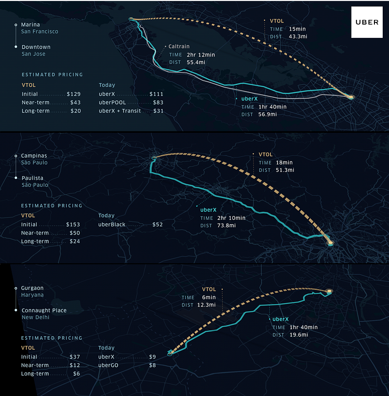
On-demand aviation has the potential to radically improve urban mobility, giving people back time lost in their daily commutes.
Sure ?
Source : Fast-Forwarding to a Future of On-Demand Urban Air Transportation – Medium
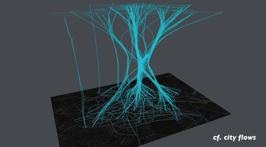
Throughout our exploratory design process we created a range of visual experiments in order to dig into the bike data, find and highlight interesting patterns, and select appropriate mappings and visualizations.
Source : cf. city flows – Comparative visualization of urban bike mobility – Urban Complexity Lab

Using real-time sensor data generated by connected vehicles, the HERE Open Location Platform will offer drivers a real-time depiction of the road environment that can be accessed through four services, providing valuable, timely insight into the driving experience.The services – HERE Real-Time Traffic, HERE Hazard Warnings, HERE Road Signs and HERE On-Street Parking – provide up-to-date information on everything from potential road hazards, to traffic updates and on-street parking.The services are available to any automaker, municipality, road authority, smartphone maker or app developer to license.
Source : HERE first to unveil services from sensor data of multiple car brands – HERE 360


Pokémon is taking over the world. Again.
Source : ‘Pokémon Go’ is already bigger than Tinder, and it’s about to overtake Twitter